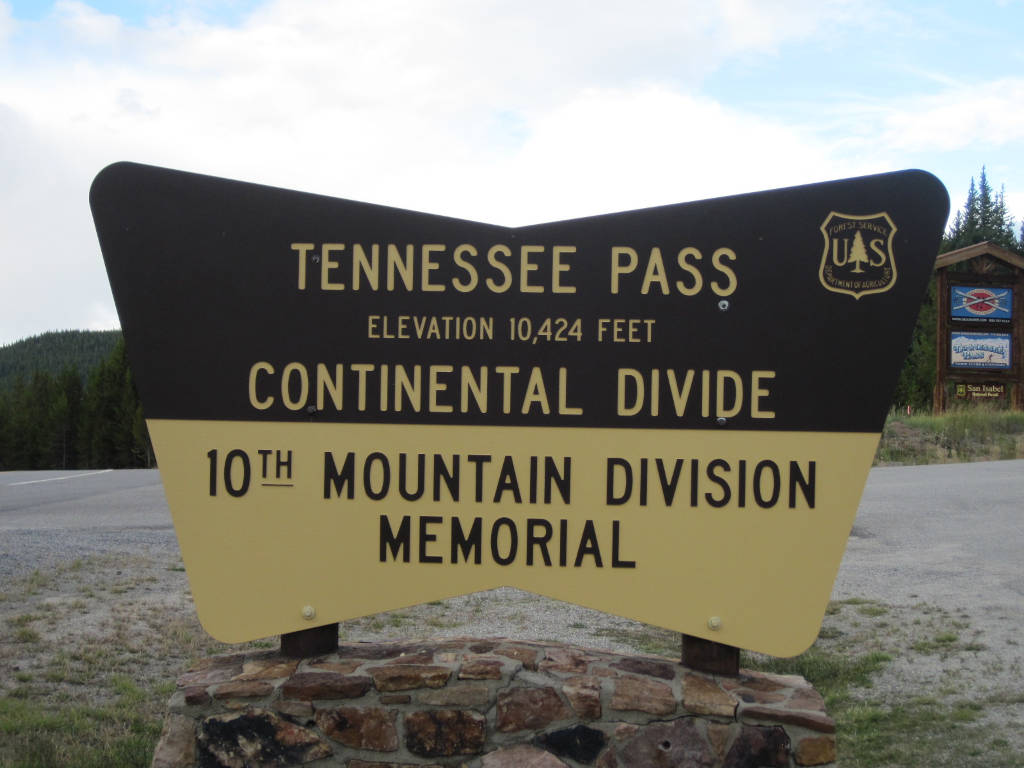
Tennessee Pass
You’ll find Tennessee Pass located between Leadville, CO and Interstate 70. This mountain pass does cross the Continental Divide, but it is not as steep as some of the other passes over the divide like Loveland Pass or Independence Pass.
If you came here during the 1940s, you would have found the troops of the 10th Mountain Division training on the slopes of what would eventually become Ski Cooper. These troops were stationed at Camp Hale on the northern side of the pass. You can still ski and snowboard at Ski Cooper, and you will also find a memorial for the 10th Mountain Division at the summit of Tennessee Pass. You’ll see the remnants of the old Camp Hale military installation just a short distance up US Highway 24 from the pass’s summit.
Seasonal Info
Highway 24 over Tennessee Pass is open year-round, and rarely closes for weather during the winter months.
Tennessee Pass Stats
- Road Elevation: 10,424'
- Surface: Paved
- Mtn Range: Sawatch, Mosquito Ranges
Alternate Routes – If Tennessee Pass is closed, you may be able to use HWY 91 -> I-70 as an alternate route (Fremont Pass). This route is located to the east of the pass, and will intersect with I-70 at the Copper Mountain exit.
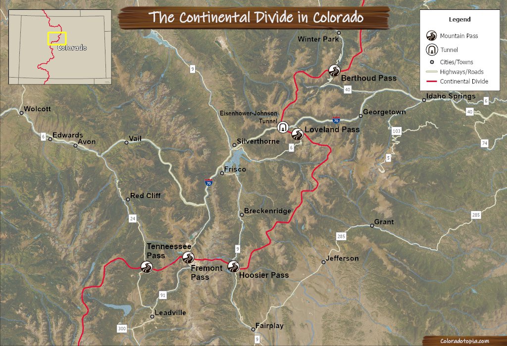
Photo Gallery
Recreation on Tennessee Pass
Ski Cooper is located at the summit of the pass, and this is also where you will find the Nordic skiing center. The Tennessee Pass Trailhead is located across the highway from the Ski Cooper entrance, giving hikers access to the Colorado Trail. There are also a handful of other trailheads in this area. This section of the trail is part of the Continental Divide Trail which runs the full length of the divide through the US.
The Camp Hale Campgrounds are located on the northern side of the pass, within the Camp Hale area.
Summer
- Camping
- Cycling & Mountain Biking
- Fishing
- Hiking
- Horseback Riding
Winter
- Skiing & Snowboarding
- Cross-Country Skiing
- Snowmobiling
- Snowshoeing
Summer
- Camping
- Cycling & Mountain Biking
- Fishing
- Hiking
- Horseback Riding
Winter
- Skiing & Snowboarding
- Cross-Country Skiing
- Snowshoeing
- Snowmobiling
Tennessee Pass FAQ
We have measured the distance of Tennessee Pass at 8.7 miles. This measurement only includes the highest portion of the pass, starting just above Camp Hale on the eastern side.
The pass splits the Sawatch Range (on the west side of the pass) and the Mosquito Range (eastern side).
Union Pacific bought the railroad line in 1996, and the last train over Tennessee Pass was on August 23, 1997.
Ski Cooper
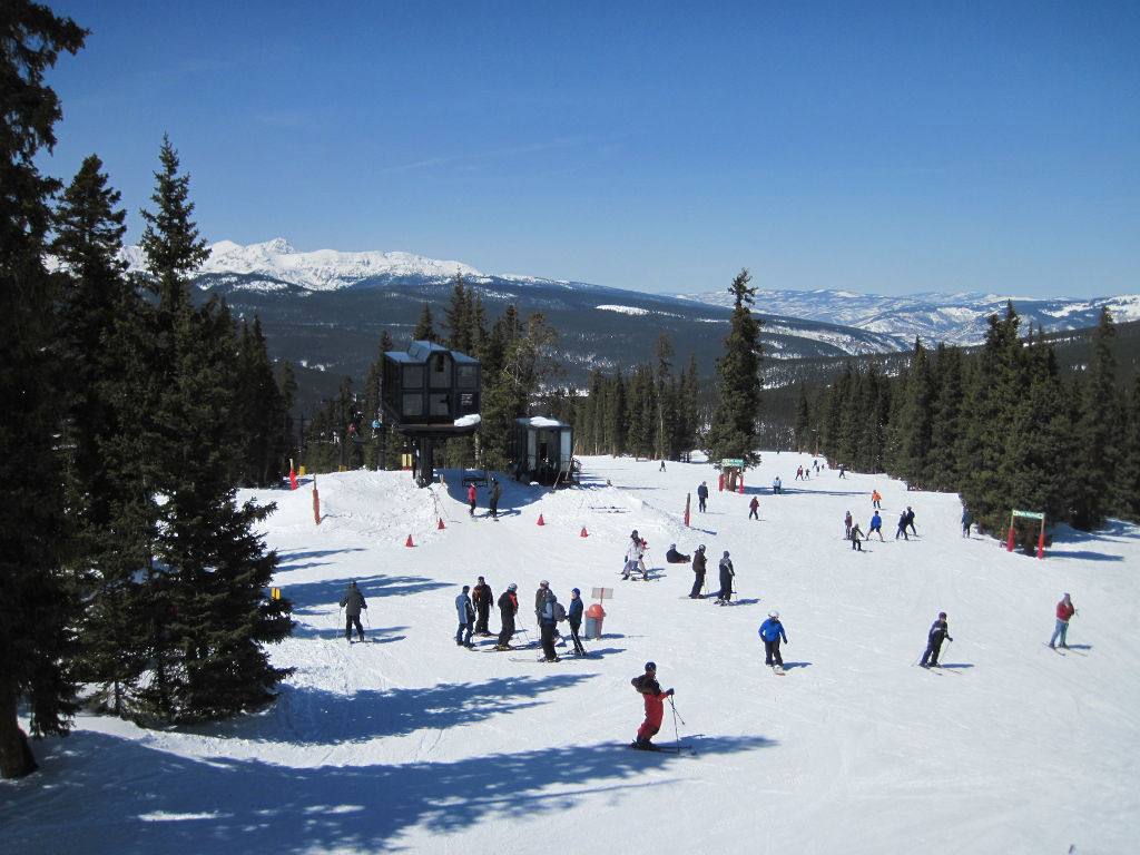
Before this became a ski area, this mountain served as the training grounds for the 10th Mountain Division ski troops who trained at Camp Hale during WWII.
See more info about Ski Cooper here: Ski Cooper.
Tennessee Pass Nordic Center
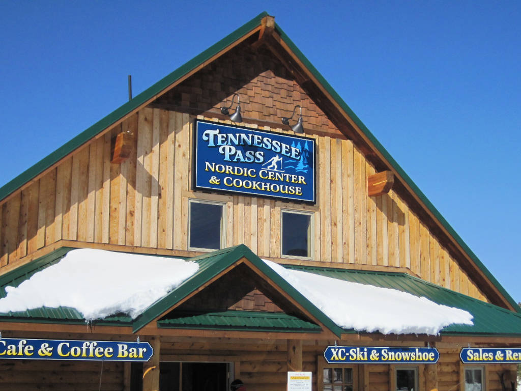
The Nordic Center uses the same entrance from the highway as Ski Cooper, and it is located just to the south of the Ski Cooper base area. Gear rentals and refreshments are available on-site here, as well as up to 27+ kilometers of groomed trails.
10th Mountain Division Memorial
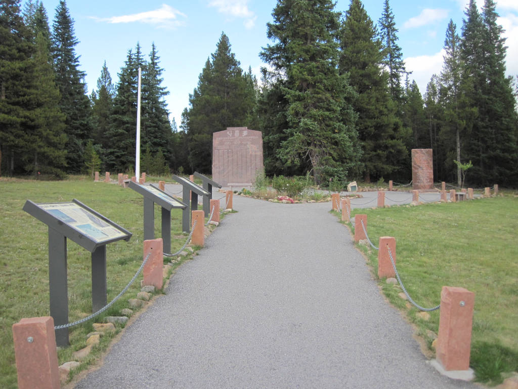
Located at the top of Tennessee Pass, this memorial is dedicated to the soldiers of the 10th Mountain Division who trained at Camp Hale. There are two memorial markers here and a series of placards. This is located right at the entrance to Ski Cooper.
The original memorial was dedicated at a ceremony on Saturday, May 30, 1959.
Tennessee Pass History
This area was a big part of the mining boom in the 1800s, and it was being surveyed for railroads by 1872. Two companies, The Kansas, Colorado & Utah Railway & Telegraph Company, and the Atchison, Topeka, & Santa Fé Railway both sent engineers here to survey the route.1
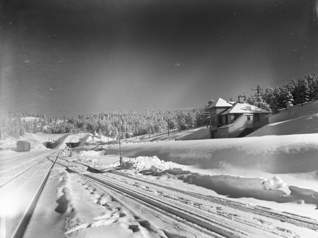
The first railway here, built in 1881 by the Denver and Rio Grande Western Railroad Company, went directly over the top of the pass.2 The first tunnel was built jointly by two companies in 1890: Denver & Rio Grande Western Railroad and Colorado Midland. This tunnel was located about 200 feet below the summit of the pass.3
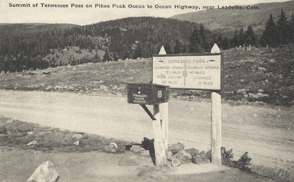
A road over the pass had already been built by the turn of the century. There are references to the Tennessee Pass road from as early as 1896.4
Attempts were made to keep the pass open during the winters throughout the 1920s, but these were unsuccessful every year. The first winter that the pass was able to stay open uninterrupted was the winter of 1929-1930.5
A newer railroad tunnel was built in 1945, and an opening ceremony was held on Sunday, Nov. 4th.6
The presence of the railroad and roadway over this high altitude pass made it an ideal location for an army base that could be dedicated to training troops in this kind of weather. Camp Hale was established on the northern side of the pass at the beginning of World War II. This is where the 10th Mountain Division and other military units would train. This former base is now designated as a National Monument.
The highway was still a gravel highway during the 1950s, but was paved by no later than 1964. 7
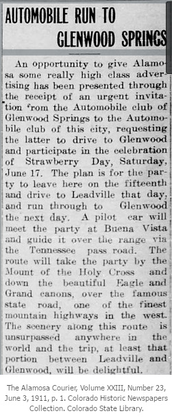
Below: An invitation from the Automobile Club of Glenwood Springs to the Auto Club of Alamosa, to come over Tennessee Pass and play.
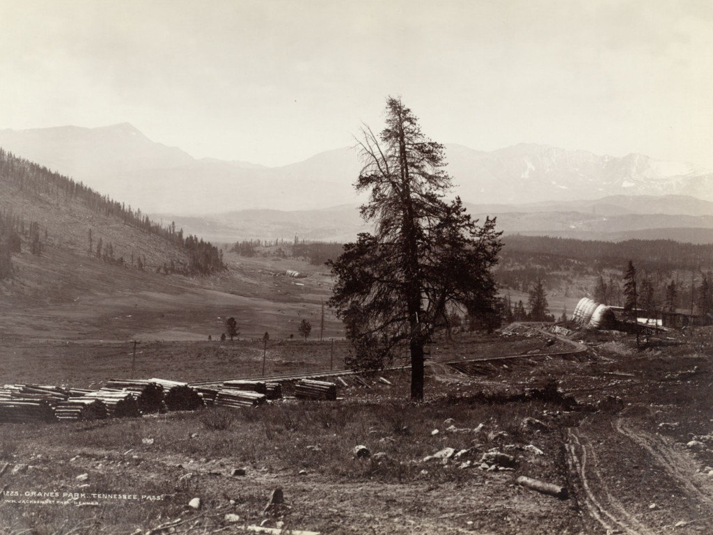
The photo below looks south on Tennessee Pass from just above Cranes Park. Piles of railroad ties can be seen on the ground, while Mount Massive can be seen in the distance. The Crane Park Trailhead can now be found in approximately the same spot.
Tennessee Pass Railroad:
The Tennessee Pass railway was important to the Western Slope of Colorado for roughly 100 years. Other routes have been preferred at times, and this is among the reasons that you won’t currently find any rail traffic traveling over the pass.
The railway over Tennessee Pass is not currently operational. The line is owned by Union Pacific, and there have been recent discussions to re-open it. Part of this railway is still used for tourists to take scenic rides through the Royal Gorge near Cañon City, CO.
Directions from Denver
To get to Tennessee Pass from Denver, just take I-70 to Exit 171 (Minturn, CO) and head south on Highway 24.
To get here from Leadville, just take Highway 24 north, and you will head over the pass.
- Located on Highway 24 between Leadville and Minturn, CO.
Did You Know?
The Arkansas River begins on the southern side of Tennessee Pass. Tennessee Creek and the east fork of the Arkansas River meet just to the south of this mountain pass. You’ll see a sign here marking the Arkansas River headwaters.
1. Out West, September 5, 1872, p. 9. Colorado Historic Newspapers Collection. Colorado State Library.
2. Leadville Daily Herald, January 1, 1882, p. 5. Colorado Historic Newspapers Collection. Colorado State Library.
3. Wikimedia Foundation. (2023, September 26). Tennessee Pass (Colorado). Wikipedia. Accessed 1.27.24. https://en.wikipedia.org/wiki/Tennessee_Pass_(Colorado)
4. The Herald Democrat, February 18, 1896, p. 8. Colorado Historic Newspapers Collection. Colorado State Library.
5. The Steamboat Pilot, May 9, 1930, p. 8. Colorado Historic Newspapers Collection. Colorado State Library.
6. The Eagle Valley Enterprise, Volume 47, Number 3, November 9, 1945, p. 1. Colorado Historic Newspaper Collection. Colorado State Library.
7. The Eagle Valley Enterprise, Volume 66, Number 34, June 3, 1965, p. 1.
Images Credits: Coloradotopia.com, Denver Public Library Special Collections (Ralph Hallock, William Jackson) [CRRM-2012.285.0668][WHJ-1475], Google Maps, | More info